3D Scanning: Replicating the Real World in a Virtual Space
July 1, 2024

Incomplete, outdated, or nonexistent site and facility drawings are a common challenge for owners and facility managers. Without accurate documentation, planning new projects or updating existing buildings can face delays, sometimes stretching design schedules by days or weeks. When every day counts, owners and design teams can’t afford repeated site visits to view and measure existing conditions. That’s where 3D scanning comes in, capturing precise measurements while maintaining accuracy, generating a comprehensive as-built point cloud of an entire site.
How does it work?
A technician arrives at the project site with a scanner and walks the area to determine the best plan for capturing the site. Once established, the technician begins scanning from one point on the site, with the scanner taking a 360-degree image and point cloud of the area. Once complete, they move to the next scan location and begin the subsequent capture. Each scan takes several minutes, and the process continues until the entire site is captured. The whole process can take anywhere from 20 minutes to several days, depending on the size of the site and the detail required.
During the scanning process, the device’s software automatically links the images together to create one cohesive and accurate digital view of the entire site. The various scans and complete site image can be imported into many different types of software (CADWorx, Revit, Recap, Navisworks, AutoCAD, etc.) to be used by the design team, depending on the project’s needs.

Project Example
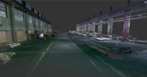
An industrial manufacturer planned to expand a production line into a building area currently used for storage. However, the only available drawings of the area were outdated and unreliable. The owner needed accurate information about how much space the material in the future production line expansion area would occupy to plan their relocation.
Coffman scanned the approximately 256,000 sf site in just two days and developed a complete 3D model of the space. This model was the foundation for a new drawing set of the future production line expansion area. Additional scans of other storage areas helped the owner evaluate relocation options for the materials once the expansion project began.
With the new drawings, the owner was better able to coordinate space requirements with the production line equipment supplier. The Coffman team imported the supplier’s equipment layouts into the previously developed 3D model to demonstrate multiple configurations and identify the most practical and efficient layout for the manufacturing space.
When to Utilize 3D Scanning:
Learn more about Coffman’s 3D Scanning services.
